Just outside of Herring Lagoon on Mitrofania Island, AK, USA, 4-AUG-2020 11.45 am ADT — The sun today reminds us that in the Aleutians and now South Central Alaska we live in a cotton wool world of low clouds and fog.
King Cove was followed by Captain Harbor and then an overnighter to Delarof Harbor on Unga Island, the site of an abandoned town. *
Ola and Michal on Crystal were there: anchored the night before. We dropped our anchor about 7 am and at 8.30 sent a text message that we were along side and they should come over for an American breakfast.
Breakfast was pancakes from EZKrust mix. The pancakes come out with the pulliness that iHop pancakes have. I cooked some apples with sugar and dug out a bottle of pancake syrup. I thought of making bacon, but Ola is almost veg…. fresh caught fish is an exception. I fried eggs for everyone except Jennifer. Ola found she likes eggs as I do: atop the pancakes..
(As I write this, two very large whales, fin I think, surfaced and crossed in front of us. )
We four went ashore in their dinghy. The town is literally falling down. It is difficult to understand that if just left alone buildings will fall to the ground overtime. Nature will reclaim or whatever term you want to use.
A church had collapsed vertically. It’s steeple still erect atop the roof sitting on the ground. The wiring was visible, strung across the rafters: knob and tube.
Unlike other abandoned settlements, we didn’t find consumer artifacts: washing machines, stoves and the like, but plenty of machinery.
As we were finishing breakfast a fiberglass gillnetter boat stopped by to say hello and tell us about the settlement.
It had been a thriving town while there was cod to fish, then the Apollo gold mine was there. There was good-sized school, a post office and stores. The last family left in 1969.
Ola and Michal took pictures. Ola and Jennifer harvested some rhubarb. I wandered over to school but left when found the bushes had many planks with nails sticking out hidden in them.
While Ola cooked dinner aboard Crystal for us (fresh caught salmon, capers, sour cream and garlic) we learned that Michal was on his second circumnavigation. They supported themselves as a charter boat selling space aboard for ”short ” legs. Their clients are generally Poles; they are the only Polish boat they know of doing this.
Around 8pm, Jennifer and I raised anchor and motored around the corner to better holding. An hour later, Crystal raised anchor for a three-day sail east. They want to be on the east side of Vancouver Island by the beginning of October and do sightseeing along the way.
All of the islands and land we move along is newly formed. There are no naturally-occurring trees. Trees that are hand planted do not reproduce, though those trees live their full life time: more than a hundred years for some of the cedars we’ve seen.
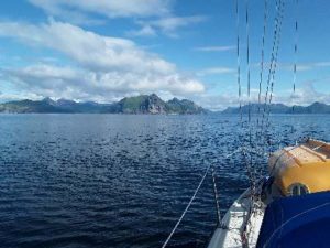
Most of the islands are volcanoes. From a distance it is instantly apparent. Some of our anchorages are calderas. The edges have not yet been rounded. The shore can be made of rounded stoves more than a foot in diameter. Sand beaches are rare.
The next morning was back to cotton. Visibility would at times drop to yards. AIS* tells us about vessels transmitting AIS information, like us. The electronic charts tell us about the water and the land and radar fills in the rest, including approaching rain.
Whether under sail or motoring, most of the the land we passed is hidden in fog or clouds. Electronic charts make navigation possible.
Generally, the clouds will lift and we’ll see the land but not the peaks. By looking at the height of the peaks we figured out that oftetimes the clouds will lift to about 800 feet. We feel as if we are seeing the entire island, minus a little bit. Other times, the clouds will stay low: at a distance and we will see the peaks but not the land. The peaks are dramatic. Many are volcanic and part of the Pacific Ring of Fire.
Sometimes, and it has only happened twice since we’ve been here, the skies will be clear and blue. This has never lasted for more than six of the sixteen hours of sunlight. Then we see where we are. The land is breath taking, if I haven’t used that term too much already.
In the cotton wool world, I reflect on how one would make our transit without the electronics we use. Could it really be done?
The big distances could be done. Celestial navigation and a compass can get you across the big distances. There are times when we can’t do a sighting for a few days. At sea this can work. How would we have gotten around here?
I guess head in the right direction, keep a track of speed and distance — dead reckoning, and then wait until there is sufficient visibility to head towards land and hope you can figure out where you actually are.
Charts, in days past, had drawings of what places looked like from sea, so that you could better figure out where you actually were.
When I was a teenager, we were returning from a sail to Middle Ground in Long Island Sound when the fog closed in. We sailed by compass and as we got close to land, I saw a water tower. The exact same water tower that there is about 15 or so miles from where I figured we should be.
Although, if that was that water tower we should have turned east to get to Mount Sinai Harbor, I turned west, because we could not be where that water tower was: there was an identical water tower in Shoreham, about two miles from where I figured we should be.
How does one do that in waters one has never sailed? We know it is not uncommon to ask a fishing boats for advice, we do it all the time. I guess one would hope to see another boat and ask for advice.
I started thinking about this as some of our electronics failed.
Our AIS started acting up. It continued to transmit our location but imtermittently stop talking to other devices and occassionally stop talking to all devices. It supplies non-essential info to our electronic auto-pilot and our radar. But it also supplies GPS info to our charting software as well as AIS info so we can see other vessels. In the cotton wool world we don’t see the vessels around us.
My laptop has also failed.
For AIS, we have an AIS receiver in our VHF radio and in our handheld VHF radio. Two VHF radios, and three AIS receivers.
For plotting, we have two tablets that we generally use, my laptop, which failed and Jennifer’s phone, which also have plotting software.
Soon thereafter, our Iridium started to malfunction, eventually not talking to any of the apps. But it did continue to act as a router for the other onboard electronics. It finally stopped doing that.
Because it was the router, once it failed no devices could speak to the AIS, so we did not see targets on our charts, but the radio told us where they were: distance and direction.
To make the AIStalk to the devices directly needs a laptop. With mine out of commission, I was able to pat myself on the back, because I loaded the AIS device management software, vmAIS, onto Jennifers’s laptop as part of the prep for the Seattle-Hilo trip — I hadn’t remembered doing so, but looked because I *should* have.
The AIS failure felt like software/firmware. So once the battery went completely dead we connected the device to power and it worked once again. It failed after 36 hours, but removing the battery resolved the problem. But will removing thge battery continue to do resolve the problem?
Yes, the new autohelm wheel drive started to fail: the plastic gear started to wear off its teeth. I reinstalled the 20-year old part that came with metal teeth.
Failures like this are part of sailing. It is a reminder that I can not allow single points of failure: We should carry a backup AIS transceiver ($760) and a backup Iridium Go ($1200), and we will.
We’re close enough to land and people that we’ll carry on with what we have. Mail is normally unreliable in these parts. With COVID it is more so.
We plan to be in the Homer area by the end of the first week in September. Caro Babbo is scheduled to be taken out of the water the 18th of that month. Barring sustained bad weather, we have plenty of time to sight see along the way.
*Beware of the Coast Pilot: it is now FIFTY years out of date when describing this harbor
**AIS — Automated Identification System
Sent from Iridium Mail & Web.